Chomolhari Trekking in Bhutan

15 Days
Bhutan
2
Moderate
  • Trip Code: Chhomolhari Trekking
  • Trip Type: Trekking
  • Max. Altitude: 4820
  • Travel Mode: Air/Coaches

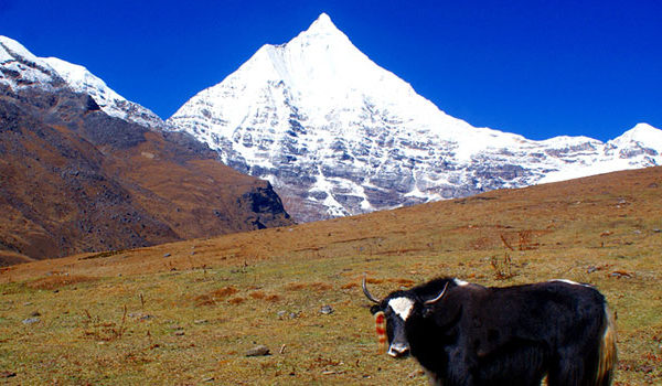
Chomolhari trek is a popular trek in Bhutan as its altitude varies from 2500 m to 4930 m and offers a wide range of landscapes, flora & fauna and spectacular views of Mt Chomolhari.

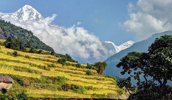
This trek begins and ends in Paro where we also visit the famous Taktsang(Tiger’s Nest) Monastery. While trekking in the beautiful Bhutanese countryside. You will enjoy the amazing Bhutanese landscape and get acquainted with its rich culture. During our trek, we also cross a few passes and are rewarded with amazing views of the Himalayas including Jichu Drake (6,989m) and Chomolhari (7,513m). Finally, you will reach Thimphu, the capital city of Bhutan and end our trip with a drive to Paro.

Overview
Trip Code Chhomolhari Trekking
Trip Duration 15 Days
Trip Type Trekking
Trip Grade Moderate
Min Group Size 2
Max Altitude 4820
Trip Start Paro
Trip End Paro
Best Season Mar-May & Sep-Nov
Transportaion Air/Coaches
Meals All meals
Acommodation Lodges/Tented Camp
Itinerary

Arrive at Paro Airport (7,000ft) where the representative from Bhutan Lha-Yul Tours & Travels will receive you and drive to the hotel. Stroll around Paro town in the evening.

A day of acclimatization. Visit Drugyel Dzong, the ruined fortress that once defended the valley from Tibetan invasions in the 17th century. On a clear day, one can get a good view of Mount Chomolhari, Mountain of Goddess (24,000 ft). Visit a typical Bhutanese farmhouse on the way back to town. Visit Ta Dzong, the watchtower that now houses the National Museum and see a traditional wooden bridge.

Spend a full day hike to Taktsang, the Tiger’s Nest. This magical monastery clings to a vertical granite cliff 3,000 ft above the valley floor. The monastery unfortunately got burnt in 1998 and has recently been reconstructed.

Drive to Drugyel Dzong and where the motor road ends the trek begins. The trail follows the river uphill through a narrow agricultural valley. Camp is just beyond an army post. Altitude 9,500 ft / 2,800 m. Distance – 17 kms. (Approx. 5 – 6 hours).

The path leads uphill through the river valley and along the river drainage. The trail passes through conifer and rhododendron forests. On the way, there is a great view of Mount Chomolhari. Camp will be set up in a meadow with stone shelter. Altitude – 12,664 ft / 3,860 m. Distance – 19 kms. (Approx. 6 -7 hours).

Follow the river and pass a small army post where the valley begins to widen again. The view of the high ridges and snow-capped peaks can be seen on all sides. At this altitude, one will also be able to see the yaks and yak herders. Camp will be set up beneath a ruined fortress at the base of Mount Chomolhari. Altitude – 13,255 ft / 4,040m. Distance – 19 kms. (Approx. 5 – 6 hours.)

One can trek up to Tsophu for fishing or hike in three directions – Mt Chomolhari and its subsidiary are directly west, Jichu Drake to the north and unclaimed summits and ridges to the east.

The trail climbs gradually to Nyilila Pass (Alt. 15354 ft / 4,680 m). Wide yak pastures can be seen all along the trail. If the weather is clear, one can get a great view of the Lingshi Dzong as one descends into the Lingshi basin. Tserim Kang and its descending glaciers can be seen at the north end of the valley. Camp is in a stone shelter. Altitude – 12,844 ft / 3,915 m. Distance – 19 kms. (Approx. 5 – 6 hours.)

During the day halt at Lingshi one can do a day excursion to Tsekha (Lahe) i.e. base camp of Jichu Drake. During the excursion, hundreds of blue sheep and musk deer may be seen on the way. Altitude – 14,764 ft / 4,500 m. Distance – 15 kms. (Approx. 4 – 5 hours.)

The trail ascends up to the Yalila Pass (Alt 15,814 ft / 4,820 m). From the pass, Mount Chomolhari, Tserim Gang and Masa Gang can be seen on a clear day. Altitude – 12,516 ft / 3,815 m. Trek – approx. 6 – 7 hours.

This trail goes along the Thim-Chhu and through forests filled with rhododendrons and water falls. The trail ascends up to the ruins of Barshong Dzong. The camp, which is a stone shelter, is just below the ruined fortress. Altitude 12,090 ft / 3,685 m. Distance – 13 kms. (Approx. 3 – 4 hours.)

The trail follows the Thim-Chhu and through a forest of thicker rhododendrons and into pastureland. Camp will be set up at a meadow. Altitude 11,247 ft / 3,428 m. Distance – 11 kms. (Approx. 3 – 4 hours.)

This is the last day of the trek and the path goes over a small pass and through forests. Wild animals may be seen along the way. Your transportation will be waiting for you at Dodena and will take you to Thimphu, the capital of Bhutan. Overnight at a hotel in Thimphu. Distance – 14 kms. (Approx. 4 – 5 hours.)

Sightseeing includes visits to the National Library, Memorial Chorten, Zilukha Nunnery and the Handicraft Emporium. Stroll through the Thimphu town.

Early morning drive to Paro Airport. Your escort will see you off at the airport.

Service Includes/Excludes

For the price write us an email: info@nectravels.com

Trip Cost Include:

» Airport pickup and drop
» All accommodation
» All Meals (breakfast/Lunch/Dinner)
» All Transportation by car van/Bus/Coaster
» One English Speaking Guide
» Sightseeing Entry fee
» Bhutan Travel Permit
» Equipment: Trekking tents, Dining tent, Kitchen Tent, Toilet Tent, Table and chairs, Mattresses during the trekking
» All Food for trekking ( Breakfast, lunch, dinner) prepared by our cook
» Staff: 1 Trekking Guide, 1 Cook, 1 Kitchen & necessary porters
» All transportation by car/ van/ bus
» Trekking crews of insurance
» Trekking allowance, food allowance for trekking crews


Trip Cost Exclude:
» Airfare
» Bhutan Visa fee (USD 20.00)
» Tourism Development fund(TDF USD 10.00)
» Emergency Rescue evacuation
» Trekking Sleeping bag
» Personal expenses
» Tipping (Tips)
» Bar bills & beverage


Reviews

Write Review

Please rate*

Your email address will not be published. Required fields are marked *